Winter Storm Blair to Bring Heavy Snow, Ice to Central and Eastern U.S. This Weekend
As the first weekend of January approaches, the United States braces for a powerful winter storm, known as Winter Storm Blair, which is set to bring widespread snow and ice from the Central Plains to the Mid-Atlantic. This storm, which is currently developing over the northern Pacific Ocean, is expected to bring challenging travel conditions and potential disruptions throughout much of the country. With snow, ice, and gusty winds in the forecast, residents from Kansas to Washington, D.C. should prepare for winter weather that could impact their weekend plans and early-week commutes.
Where Is the Storm Now?
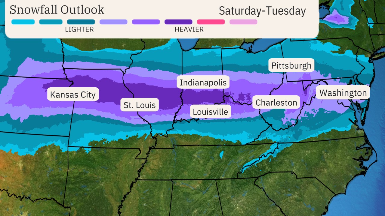
Winter Storm Blair is still in its early stages, but the disturbance that will fuel the storm is already evident over the northern Pacific Ocean. This system is expected to move into the Pacific Northwest on Friday, bringing rain and mountain snow to the region. As the storm progresses eastward, it will intensify, with low pressure developing and tracking across the central and eastern United States. The exact path of the storm remains somewhat uncertain, but meteorologists are closely monitoring the storm’s track, as this will determine which areas receive the heaviest snow and who will experience hazardous ice accumulations.
How Much Snow and Ice Can We Expect?
Forecasts suggest that Winter Storm Blair will deliver significant snowfall and ice accumulations across a broad portion of the United States. For those in the Central Plains and Midwest, a stripe of snow totaling 6 inches or more is likely. Areas that will be hardest hit by accumulating snow include northeast Kansas, parts of Missouri, the southern halves of Illinois, Indiana, and Ohio, as well as northern Kentucky. These regions could see dangerous travel conditions, especially on Sunday and Monday when snow is expected to be heaviest.
In the mid-Atlantic, snow is expected, though totals are still uncertain at this point. Light to moderate snow accumulations are possible, but it’s too early to predict exactly how much will fall. For now, residents in cities such as Washington, D.C., and Baltimore should be aware that wintry conditions will likely affect travel and daily routines. Snowfall and ice could continue into Monday morning, causing potentially hazardous conditions for commuters.
The storm also poses a significant threat of ice accumulation. Areas experiencing sleet and freezing rain could face dangerous travel disruptions, particularly in central and southern Kansas, the Ohio Valley, and the Appalachians. In addition to travel issues, ice could lead to broken tree limbs and scattered power outages. While the details are still being fine-tuned, it is clear that Winter Storm Blair has the potential to cause widespread impacts across these regions.
When Will the Storm Hit?
The timing of Winter Storm Blair is crucial, and meteorologists are predicting that the worst of the weather will unfold from Saturday through Monday. Here’s a closer look at the expected timeline of the storm:
Saturday to Saturday Night
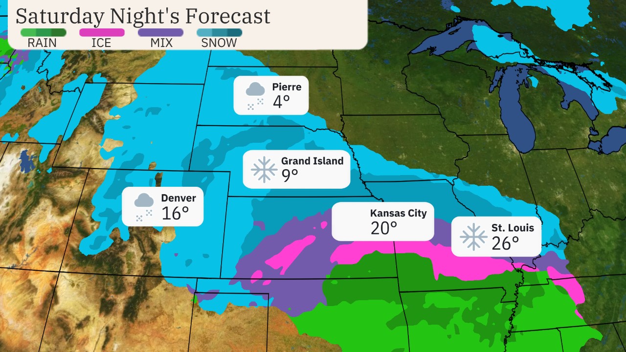
The storm’s initial snow and ice will begin to emerge into the Plains on Saturday. Snow will mostly affect the northern and central Rockies during the day, but as the storm tracks eastward, snow and ice will spread into the central U.S. by Saturday evening. By Saturday night, areas such as Kansas City, St. Louis, and Wichita, Kansas, may experience increasingly hazardous travel conditions as snow and ice intensify. Drivers in these cities should be especially cautious, as the storm is expected to impact roads and visibility in the evening hours.
Sunday to Sunday Night
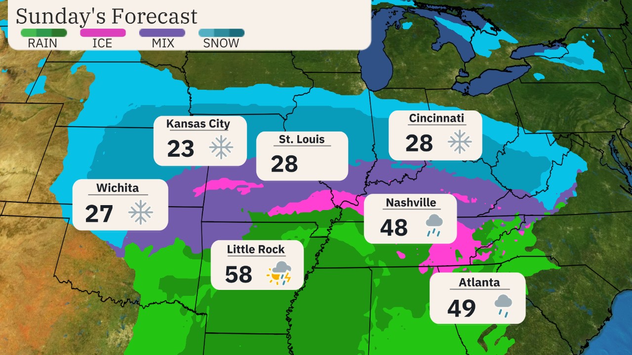
On Sunday, snow is likely to stretch from Kansas to Ohio, with the Interstate 70 corridor being a key area to monitor. Areas near and around I-70 will see snow, which could be heavy at times, accompanied by gusty winds. The combination of snow and wind could reduce visibility significantly, creating dangerous conditions for anyone traveling along this major route. South of the heavy snow, sleet, freezing rain, and snow will create a wintry mess that could affect areas from northeast Oklahoma and southeast Kansas to parts of the mid-Mississippi Valley, Ohio Valley, and Appalachians.
Travelers throughout these regions should be prepared for treacherous conditions, and officials are advising people to avoid non-essential travel on Sunday and Sunday night. Major cities like Cincinnati, Kansas City, Louisville, and St. Louis are likely to see considerable impacts, so residents should plan ahead and check forecasts frequently.
By Sunday night, the storm’s wintry weather will likely spread as far east as the mid-Atlantic, affecting cities like Washington, D.C., and Baltimore. Snow and ice may accumulate in these areas, leading to slippery roads and potentially dangerous travel conditions as the weekend draws to a close.
Monday
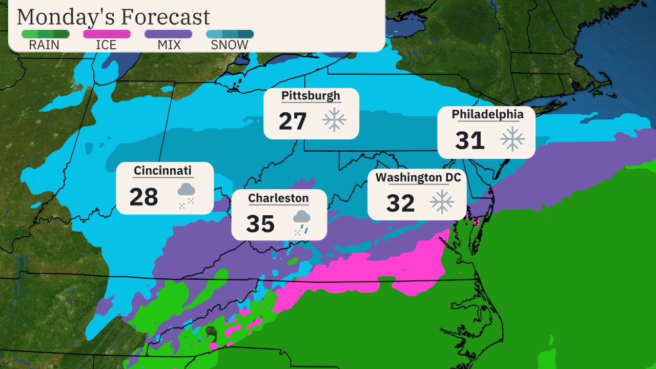
As the storm moves eastward into Monday, snow and ice will continue to cause disruptions for the morning commute, especially in the mid-Atlantic region. Cities such as Baltimore, Charleston (West Virginia), Cincinnati, Philadelphia, Pittsburgh, and Washington, D.C. will likely experience wintry weather throughout the day, with conditions varying from snow to sleet and freezing rain.
Monday morning commuters should expect delays, especially in areas that have experienced snow overnight. Snow will continue to impact parts of the Ohio Valley and Appalachians, causing hazardous conditions throughout the region. Meteorologists are advising residents to monitor weather updates closely as the storm progresses, as conditions could change rapidly.
By Monday night, the storm’s wintry weather will taper off from west to east. However, lingering snow and ice could still affect travel in some areas, particularly in the central and eastern parts of the U.S. Those with travel plans early Tuesday morning should be aware that roads could still be slippery, and conditions may remain challenging in some locations.
Read More:
- 10 People Injured in Shooting Outside Queens Nightclub: Authorities Investigate Attack
- Soldier Killed in Tesla Cybertruck Explosion Near Trump Hotel
- Driver Plows Into New Year’s Crowd in New Orleans, Killing 10; FBI Probes ‘Act of Terrorism’
What Are the Risks of Ice and Snow?
One of the most significant concerns with Winter Storm Blair is the potential for dangerous ice accumulations. In areas where sleet or freezing rain occurs, travel could become especially treacherous. Ice on roads can make driving hazardous, and even short trips could become dangerous if conditions worsen quickly.
In addition to travel problems, ice accumulations could cause other disruptions. Downed tree limbs and power outages are possible, particularly in areas that experience heavier ice. It is still too early to predict exactly where these issues will occur, but residents in the affected regions should remain prepared for the possibility of service interruptions.
Snowfall, while not as dangerous as ice, can still cause significant travel problems. Areas that experience heavy snow will see reduced visibility and slick roads. Snow accumulations of 6 inches or more are expected across parts of the Central Plains and Midwest, and these conditions could make travel slow and hazardous. Additionally, gusty winds could make driving even more challenging by creating blowing snow and reduced visibility.
What States do Ice Storms Occur in?
Ice storms can occur in many parts of the United States, particularly in regions where cold air from the north meets moisture from the south. These storms are most common in areas where temperatures hover around freezing, leading to freezing rain that coats surfaces with a dangerous layer of ice. While ice storms can happen in various parts of the country, certain regions are more prone to these winter weather events due to their geographical location.
A winter storm is expected to begin impacting the Central Plains by Saturday night, with heavy snow and significant icing potential spreading eastward to the Mid-Atlantic by early next week. See our latest Key Messages below. ❄️ pic.twitter.com/habFiutQEO
— NWS Weather Prediction Center (@NWSWPC) January 2, 2025
The Midwest
In the Midwest, ice storms are frequently observed. States like Missouri, Illinois, Indiana, Ohio, Michigan, Kentucky, Wisconsin, Iowa, Kansas, and Nebraska are particularly susceptible. These areas often experience a mix of snow, sleet, and freezing rain during the winter months, with ice storms causing significant disruptions to travel and infrastructure. When cold air from Canada meets moisture from the Gulf of Mexico, freezing rain can accumulate quickly, creating hazardous conditions.
The Central Plains
The Central Plains also see their fair share of ice storms, especially in Oklahoma, Texas, and Arkansas. While these states are more commonly associated with severe thunderstorms and tornadoes during the warmer months, they are equally vulnerable to winter ice storms. In these regions, ice can cause power outages, hazardous road conditions, and damage to trees and power lines. Ice storms are less frequent here compared to the Midwest, but they still pose significant risks during colder winters.
The Northeast
The Northeast is another region where ice storms are common, especially in states like New York, Pennsylvania, New Jersey, Connecticut, Massachusetts, Rhode Island, Vermont, and New Hampshire. The combination of cold air and moisture from the Atlantic Ocean makes this area prone to freezing rain. In some years, ice storms can paralyze cities and towns, causing widespread disruptions to transportation and power systems. The ice buildup on roads and trees can create hazardous conditions, leading to accidents and tree damage.
the Appalachian Region
In the Appalachian Region, which spans parts of West Virginia, Tennessee, North Carolina, and Virginia, ice storms can also occur, especially in higher elevations. These states experience a unique set of conditions that can lead to freezing rain when moisture-laden air is lifted over the mountains. Ice accumulation in these areas can lead to severe travel disruptions, particularly in the higher altitudes where snow and ice tend to accumulate more heavily.
The Southeast
Although ice storms are most commonly associated with the central and northern parts of the U.S., the Southeast can also experience them, albeit less frequently. States such as Georgia, Alabama, and South Carolina are occasionally affected by ice storms, typically during particularly cold winters. While these areas are less accustomed to winter weather events, the combination of freezing rain and wet conditions can still cause significant damage when it does occur.
Overall, ice storms can affect many states across the U.S., with the Midwest, Central Plains, Northeast, Appalachians, and even parts of the Southeast being particularly vulnerable. These storms are dangerous due to the ice they deposit on roads, power lines, and trees, which can lead to widespread disruptions. While ice storms are more common in certain regions, they can strike unexpectedly, making it important for residents in these areas to be prepared during the winter months.
Prepare for Winter Storm Blair’s Impact
As Winter Storm Blair tracks across the country this weekend, it is clear that the storm will bring a wide range of winter weather hazards to the Central and Eastern U.S. From snow to ice, the storm is poised to affect millions of people, disrupting travel plans and daily activities.
Residents in the storm’s path should stay updated on the latest forecasts and be prepared for winter weather conditions, especially on Saturday and Sunday. Traveling during this period should be limited to essential trips only, as hazardous conditions are likely to persist in many areas.
Winter Storm Blair serves as a reminder of the unpredictable nature of winter weather. Whether it’s snow, ice, or freezing rain, this storm could have far-reaching effects, so staying informed and planning ahead will be crucial in minimizing the impact of the storm. As the weekend approaches, residents across the affected regions should take steps to ensure they are prepared for the worst and remain vigilant throughout the storm’s progression.


